Shakira Shareef
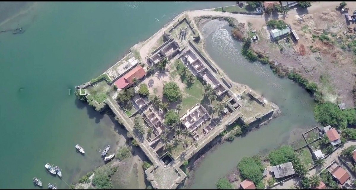
The Colombo Port City is known by all — but not many are aware of an ancient, once prominent port and bazaar city in Mannar. And with good reason: today, it lies submerged in the Indian Ocean.
Here are six things we know about Mannar and its history.
-
It’s Prehistoric
Mannar’s fame as a significant shipping and harbour point in the Indian Ocean has its roots in prehistory. Evidence gathered in excavations carried out by prominent archaeologist Professor S. U. Deraniyagala, has pointed at prehistoric human settlements of the Iranamadu composition. In ancient Sri Lanka, the most famous and significant port was in Mannar, aka Mathota. IT was also termed Medettu on the map sketched by Ptolemy in the 2nd century AD.
The renowned port has been chronicled in the Mahāvaṃsa since the period of King Vijaya, and excavations have unearthed rich evidence of copper, iron and many other metal artefacts. It’s believed the Mannar port even exported Seruwila copper to India.
Various stone inscriptions, including an evergreen song inscribed at Sigiriya, detail the island of Mannar and how large the city used to be.
-
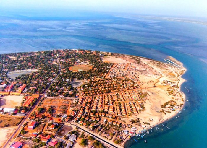
The Great Port of Mahaththitha: The Horseshoe Shaped City
The term ‘Mannar’ is acquired from the Tamil and translates to “lands of pearls.” Records suggest that the ancient buildings of Mathota harbor were 400 metres away from the beach, and there were two moats and a wall around it. The trade city, too, consisted of two moats — forming the shape of a horseshoe.
Based on the evidence, by 1800 BC, Mathota was a settlement of the Middle Stone Age, but it transformed into protohistory by the 2nd century BC.
Quoting author C. W. Nicholas in ‘Information about Ancient places from Historical and Medieval Ceylon’, Professor Somapala Jayawardena has said, the port in front of Mannar was given different names in inscriptions and Sinhala literature, and they are Mahawoti, Mahaputu, Mawathuthota, and Mahapatana.
It was called Manthottam in Tamil. Although the evidence-based port city dates back to the era of Anuradhapura, later it submerged. Its ruins are found in Manthai Maha Pasgoda, and the Thiruketheeshwaram Hindu Temple is built on it. Like Anuradhapura and Polonnaruwa, Mahathiththa was also surrounded by a wall. Moreover, all the products, such as gems, pearls, cinnamon, elephants, and spices, exported from Sri Lanka, were handled through this port.
-
A Princess, King Elara And An Invasion
As mentioned in the Mahavamsa, the royal princesses had landed at Mahathota harbor to attend the coronation ceremony of Prince Vijaya (543-504 BC). During the war between Kings Elara (205-161 BC) and Dutugemunu, troops entered the country through Mahathota harbor to support King Elara. During the reign of King Walagamba (89-77 BC), seven invaders entered the country through Mahathota, defeated the king, and captured Anurapadhura. Also, there was a kovil at this place during the reign of King Sirimeghavarna (301-328 AD). As mentioned in Mahavamsa, South Indian invaders, including Pandya, Pallava, and Soli, entered Sri Lanka from the Mannar Port.
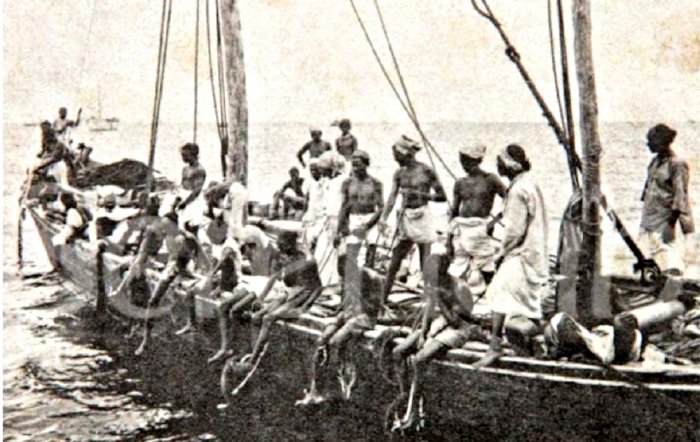
By the 6th Century BC, this port received enormous importance as a commercial port. The Mannar port welcomed ships, including Persian, Axumite, Adulis, Indian, Chinese, and many other ships from the Eastern region along with Merchants. At the time, Mannar was a busy trading port. It was active from 2nd century BC to 13th century AD, making it a port with 1,500 years of success.
-
The Kovil That Replaced The Harbour
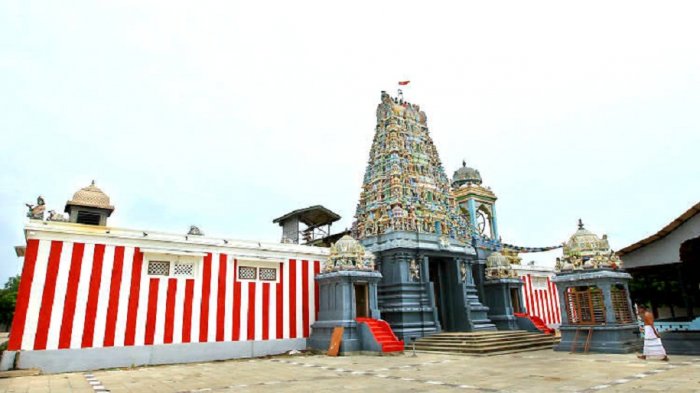
The kovil built on the ancient port city of Mathota dates back to the 11th century. But the Portuguese demolished the Buddhist and Hindu shrines, and while they were at it, destroyed this kovil. It is said that the stones obtained from this temple were used in building the Mannar Fort. The temple’s ancient base and other religious objects were found in 1894, but only in 1903 was the temple reconstructed. Although Sinhala and Tamil inscriptions and the head of a Buddha statue were found in the temple’s ground, it is now a famous kovil in Mannar.
-
A Visit By Robert Knox
“We finally reached the fort Arippu after traveling to many villages. It was a Saturday in October 1679. The captain’s hospitality was excellent. It was home to people of Christianity.“
— Then Heladiva, Prof. David Karunaratne
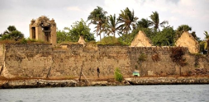
Robert Knox discusses in his book how he reached Fort Arippu while fleeing the upcountry. The fortress was located in Mutharipathhuraya, which is from the West Grama Niladari Division of Arippu. The Portuguese initially built this, but when Dutch captured the Portuguese’s fortress, they lost Fort Arippu to Dutch. This was a relatively small fort with two bastions, but the Dutch renovated it for their purpose.
The fort was used to handle pearl mining. The relics of the artillery bastions in the Northwest are somewhat intact. Coral limestone, brick, and rocks have been used to construct the Fort. The church inside the fortress and the relics from the Fort wall can still be seen. There is an old well near the fort and a tomb of Charles Leyas, a banker who died on April 14, 1878.
-
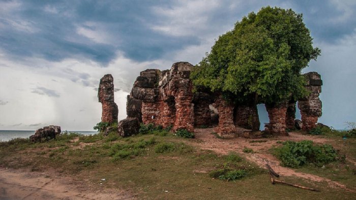
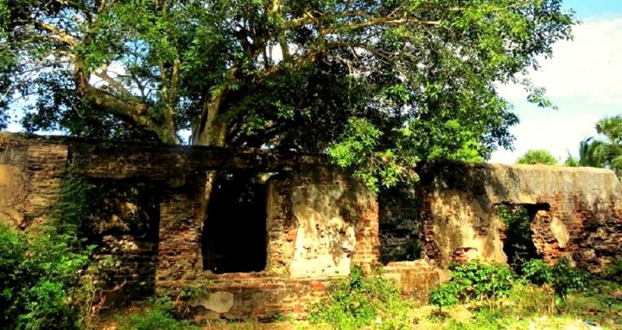
The Doric Bungalow
This bungalow was built to accommodate Governor Fredrick North when he visited Mannar to inspect pearl extraction. Rev. James Cordiner, a chaplain attached to a military garrison in Colombo in 1804, also visited this building and wrote mentioning that the government obtained 75,000 pounds from pearl mining in 1804. In 1802, Governor Edward Barnes issued an order to renovate government buildings in Mannar, including the Doric. Although these stunning buildings have now become ruins, they once adorned the beaches. Some parts of the ground floor can be seen today, even though the rear has been destroyed by sea erosion.
All the doors and windows of the building have been furnished with arches. Of the four small bedrooms downstairs, there are only two of them to be seen today. Stairs have been constructed in the middle of the building to reach the upper floors, which consisted of two terraces, a large dining room, and the governor’s bedroom. It is also suspected that there may have been other buildings nearby, besides this bungalow, for its workers.
This remarkable building, which is reminiscent of the colonial era, can be reached by taking a turn near the Murunkan junction of Medawachchiya-Mannar road and going to Silawathura to get to Arripuwa. It was built by Najal, a local engineer, in 1802. Governor North himself laid the foundation stone of this building on March 18, 1802, and it was completed in 1804. The building was named after Doric towers that were from Greek tradition because these towers were used in the construction.